
If I want drone mapping work in U.S. construction, I need more than flight skill. The short version is this: I need FAA Part 107, site safety training such as OSHA 10 or 30, and proof that I can turn flights into usable map and survey files.
Here’s the article in plain English:
- Drone mapping jobs usually fall into 3 role types: UAS operator, survey tech, and reality capture/VDC support.
- Employers hire for output, not just flight time. They want orthomosaics, point clouds, cut/fill reports, as-builts, and CAD/GIS-ready files.
- Part 107 is required for paid drone work in the U.S. The test fee is about $175, and recurrent training is due every 24 months.
- OSHA 10 or OSHA 30 is often needed to get on active construction and energy sites.
- Accuracy matters a lot. Many jobs want ±1–3 cm results, which means proper use of GCPs, checkpoints, overlap, altitude, and GSD.
- Software skill helps separate candidates. Common tools include Pix4D, DroneDeploy, Agisoft Metashape, ArcGIS, AutoCAD, and Civil 3D.
- Some survey work has legal limits. Boundary surveys and some topo mapping may need a PLS or work under PLS oversight.
- A portfolio is part of the hiring process. I should show a full workflow: flight plan, ground control, accuracy notes, and final deliverables.
A few numbers stand out. As of 2026, the U.S. has more than 368,000 Part 107 certificate holders, so the license alone won’t set me apart. And for paid work, flying without Part 107 can bring FAA penalties of up to $32,666 per violation.
If I were starting from scratch, the path is simple: get legal, get site-safe, then prove I can deliver survey-grade data.
The Invisible Job Market for Drone Mapping
sbb-itb-aa28329
Core skills employers look for in drone mapping workers
Employers don’t hire for flight time alone. They hire for usable data. Whether the role is remote pilot, survey tech, or VDC support, the same three skill blocks show up again and again: flight, measurement, and delivery.
Flight operations, airspace rules, and job site safety
You need to be comfortable flying both manually and through automated missions. Automated flights often use grid or crosshatch patterns for 3D modeling, and linear paths for corridor surveys. Just as important, you need to know the rules: stay under 400 feet AGL, keep VLOS, and handle fail-safes, pre-flight checks, and flight logs with care.
Emergency response is part of the job too. If the drone loses GPS, you may need to switch to ATTI mode. If the communication link drops, Return-to-Home (RTH) may kick in. That kind of stuff can’t feel new when you’re on an active site.
Site access is another piece many people miss. OSHA 10- or 30-hour construction safety certification is showing up more often as a job-site requirement, even for people with strong pilot credentials. You also need to respect the aircraft’s rated wind limit and set up a clear exclusion zone around the takeoff and landing area.
Safe flying is the baseline. But on a construction site, the flight only matters if the data can support grading, volume checks, and as-builts.
Photogrammetry, ground control, and mapping accuracy
This is where many candidates slip. The issue usually isn’t flying. It’s accuracy.
Construction teams often need centimeter-level accuracy (±1–3 cm). That means you need to place GCPs and checkpoints the right way and check the model against independent checks, instead of leaning on RTK/PPK alone. Flight overlap, altitude, and GSD also need to match the project’s accuracy target.
Lighting matters more than people think. Overcast days with diffuse lighting usually produce better outputs than bright sun because they cut harsh shadows and make image textures more even.
Use GCPs and checkpoints to verify centimeter-level accuracy; RTK/PPK alone is not enough.
The next step is simple in theory and harder in practice: turn that accurate model into files the project team can use without extra cleanup.
Software, GIS, and CAD skills for project deliverables
Knowing the software – and delivering files people can work with – is what helps you get hired. Here’s a quick view of the main skill areas, what they do on-site, and how people usually learn them.
| Skill Category | What It Enables On-Site | Common Training Formats |
|---|---|---|
| Flight Operations (DJI Pilot 2, DroneDeploy, Pix4Dcapture) | Systematic data capture for maps | Software-specific tutorials, manufacturer guides |
| Photogrammetry (Pix4Dmapper, Agisoft Metashape, DroneDeploy) | Orthomosaics, 3D models, volumetric reports | Online certification courses, software-specific bootcamps |
| Ground Control & RTK | Centimeter-level accuracy for grading and as-builts | Hands-on field practice, GNSS rover training |
| GIS (ArcGIS, ArcGIS Pro) | Spatial analysis, map overlays, geospatial reporting | ESRI certification, university extensions, self-study |
| CAD/BIM (AutoCAD, Civil 3D, Bentley ContextCapture) | Integrating drone data into engineering and design models | Autodesk certification, technical college courses |
In practice, Pix4D is often the pick for high-accuracy engineering work, while DroneDeploy is often used for fast progress reporting and a simpler workflow. A smart starting point is one photogrammetry tool and one GIS tool. Then add CAD skills as project needs start pushing you there.
Certifications that matter for drone mapping careers
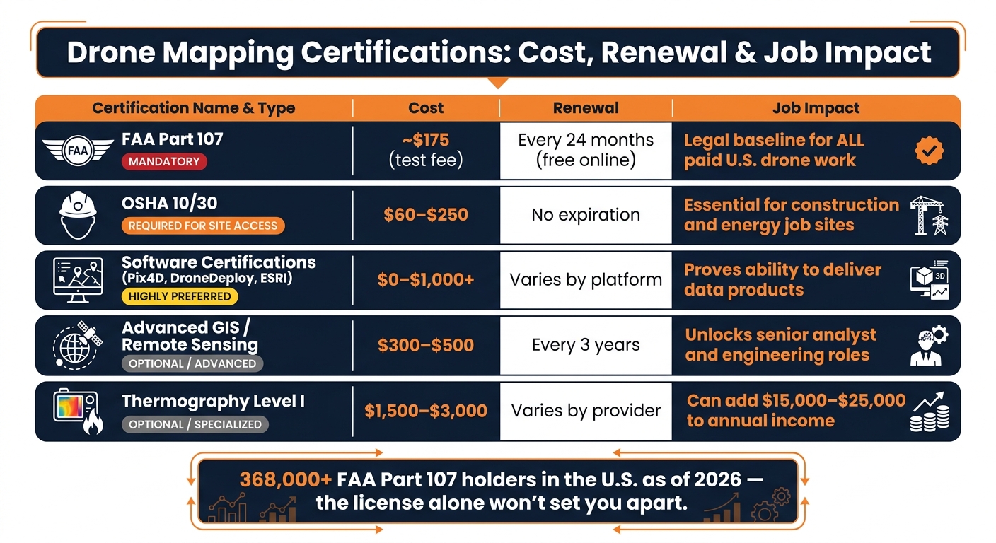
Drone Mapping Certifications: Cost, Renewal & Job Impact
Once you’ve got the core field skills, certifications start to matter a lot more. They often act as the hiring filter. In drone mapping, these credentials usually fall into two buckets: the ones you must have to work legally, and the ones that help you stand out. Knowing the difference can save you time, effort, and money.
FAA Part 107: the required starting point for paid drone work
Part 107 is non-negotiable. The FAA Part 107 Remote Pilot Certificate is the legal starting point for paid commercial drone work in the U.S. If you fly without it, you could face civil penalties of up to $32,666 per violation.
As of 2026, there are more than 368,000 Part 107 certificate holders in the U.S.. So yes, the certificate by itself may not make you stand out. But if you don’t have it, you’re out of the running for paid work from the start.
To earn it, you need to study for a 60-question aeronautical knowledge test. The exam covers:
- Airspace
- Weather
- Performance
- Emergency procedures
- Crew coordination
- Night ops
You’ll take the test at an FAA-approved testing center for about $175. There’s also a TSA background check. After you’re certified, you need to complete the free FAA recurrent online training, ALC-677, every 24 calendar months to stay current.
Basic eligibility is pretty simple. You must be at least 16 years old, able to read, write, and speak English, and physically and mentally able to operate a drone safely.
Once you’re cleared to fly legally, the next barrier usually isn’t the sky. It’s getting onto the jobsite.
Construction, mapping, and software credentials that strengthen your profile
For construction and energy work, OSHA 10/30 is often the credential employers expect for site access. In plain English: if you can’t get on the site, you can’t do the job.
Then there’s the data side. Software certifications from Pix4D, DroneDeploy, or Agisoft Metashape show employers that you can do more than fly – you can also process and deliver usable outputs. ESRI or QGIS certifications can help as well, especially if you want geospatial analysis roles.
Some work has a stricter line. If a project involves boundary surveys or official topographic maps, a Professional Land Surveyor (PLS) license is required. That’s why drone mappers on those jobs usually work under PLS supervision.
For niche inspection work, Level I Thermography can be a strong add-on. It matters for energy and utility inspections, including roofs, facades, and MEP systems. It can also add $15,000 to $25,000 to annual income. That’s a big jump for one specialty skill.
Comparing certifications by cost, renewal, and job impact
Use the table below to figure out which credential makes the most sense for the type of role you want.
| Certification | Required or Preferred | Typical U.S. Cost | Renewal | Job Impact |
|---|---|---|---|---|
| FAA Part 107 | Mandatory (U.S. law) | ~$175 (test fee) | Every 24 months (free online) | Legal baseline for all paid work |
| OSHA 10/30 | Required for site access | $60–$250 | Generally no expiration | Essential for construction and energy sites |
| Software Certs (Pix4D, DroneDeploy, ESRI) | Highly preferred | $0–$1,000+ | Varies by platform | Proves ability to deliver data products |
| Advanced GIS / remote sensing | Optional / Advanced | $300–$500 | Every 3 years | Unlocks senior analyst and engineering roles |
| Thermography (Level I) | Optional / Specialized | $1,500–$3,000 | Varies by provider | High; can add $15k–$25k to annual income |
On ABLEMKR, verified certifications, safety training, availability, and location affect job matching.
Step-by-step path to land drone mapping jobs
Start with legal compliance, safety training, and basic flight practice
The order matters here. Start in FAA IACRA and get your FTN before you book the Part 107 exam. Then add OSHA 10 or OSHA 30 so you can get on job sites.
Log every flight. Track the date, location, weather, and total flight time. That gives you a record you can show employers, and it helps you stay prepared for FAA audits. Begin in open, low-risk areas. After that, move into practice flights that look more like actual site work.
Build a portfolio with mapping outputs employers recognize
Once you can fly legally, the next step is simple: show that you can turn a flight into data a team can use. Employers don’t hire on flight hours alone. They want to see deliverables.
Use a legal practice site with some terrain change, like a local park or a permitted worksite, and fly a full photogrammetry mission. Then process the mission into a complete deliverable set: orthomosaic, Digital Surface Model (DSM), Digital Terrain Model (DTM), contour map, and a cut/fill volume report.
Your portfolio case studies should spell out the project scope, how you planned the flight, the accuracy you reached, and the final outputs you delivered. Include details on coordinate systems, datums, projections, and GCP placement. That’s the kind of stuff employers notice because it shows your data can drop into CAD or GIS workflows without extra cleanup.
Match your credentials to real project opportunities
Next, line up your skills with the kind of role you can handle right now. Job titles change from one employer to another, so widen your search. Look for roles such as UAS/UAV Technician, Survey Technician, Geospatial Analyst, and Reality Capture Specialist.
| Career Stage | Target Roles | Priority Skills | Key Certifications |
|---|---|---|---|
| Entry-Level | Drone Operator, UAS Technician | Basic flight, site safety, data capture | FAA Part 107, OSHA 10 |
| Mid-Career | Drone Surveyor, GIS Technician | Photogrammetry, GCPs, volumetrics | OSHA 30, software certifications |
| Senior/Specialist | LiDAR Specialist, BIM Lead | LiDAR processing, scan-to-BIM, BVLOS | ITC Level I (Thermal), LiDAR training |
On ABLEMKR, verified credentials and location drive project matching.
Conclusion: The fastest way to become job-ready for drone mapping work
Getting job-ready for drone mapping comes down to a simple sequence: legal access, site safety, then data delivery. The fastest route is to earn your Part 107, complete OSHA site-safety training, and learn one mapping software workflow well.
That path is also fairly low-cost to start. The $175 Part 107 exam fee, plus OSHA 10- or 30-hour training, makes for a manageable entry point into a field where employers are looking for qualified workers.
After you have legal clearance and some hands-on practice, your software output becomes the proof that matters. A portfolio built around construction-focused deliverables, like orthomosaics, volume reports, and georeferenced outputs, shows employers that you can do more than just fly a drone.
That’s where tools like Pix4D, DroneDeploy, or Agisoft Metashape come in. Skill with one of those platforms, paired with clean GIS or CAD deliverables, is what turns a certification into proof that you’re ready to work.
One last thing: keep your Part 107 recurrent training up to date every 24 months through FAASafety.gov.
FAQs
Do I need survey experience to get started?
No. You don’t need survey experience to start in drone mapping.
The first things that matter more are getting your FAA Part 107 certification, learning photogrammetry and GIS software, and putting together a portfolio.
Can I get hired with Part 107 alone?
Yes. Part 107 is required for commercial drone work in construction, but it often isn’t enough by itself.
A lot of drone mapping jobs also call for extra skills and certifications, depending on the role.
What should I include in a drone mapping portfolio?
Include sample deliverables that show your full aerial mapping workflow. That means orthomosaics, DSMs, DTMs, contour maps, volumetric measurements, 3D models, and analysis reports.
If you’re just getting started, build your portfolio with small-scale or community projects. A local park, school site, empty lot, or neighborhood drainage area can work well.
Add short case studies for each project. Explain:
- your methodology
- the accuracy you achieved
- the results you delivered
This helps people see that you can do more than produce maps. It shows you understand the full process, from data collection to final output.


